Most boaters have heard of the Chilko-Chilcotin-Fraser raft expedition. It's run commercially. There's a Hollywood movie called the White Mile about a rafting accident on the Chilko River. But questions remain. Does the trip have some of the most continuous rapids in North America, or is it just a bunch of flatwater? Is it in the forest or in the desert? Wilderness or roadside? Finally, is it a tightly held secret or a well loved classic? The answer of course, is all of the above. Most groups paddle the Chilcotin River as part of a larger Chilko-Chilcotin-Fraser or Taseko-Chilko-Chilcotin-Fraser expedition.
Respect for the land
It seems likely the reason there is little beta about this trip, is that commercial and private boating groups do not want to see damage to the land and subsequent land use closures. The reason for this description is to inform the boating public about land status and best practices, so that this run can remain accessible for the foreseeable future. Right now, boating is a well recognized activity in the corridor, but there are several potential pinch points, and it is up to the boating community to be good stewards.
The put in region is in the territory of the Tŝilhqot’in National Government. "We are the River People. The Tŝilhqot’in people have fished ts’eman (sockeye), Jaŝ (Chinook), and tislagh (steelhead) since time immemorial." (TNG website). In 2014, the Supreme Court of Canada recognized TNG land title to a portion of their traditional territory, which is a different legal status to a land claim or reserve. The TNG owns and manages this area and has its own land guardians. Generally the TNG is welcoming to boaters, but it's a good idea to check their website or give them a call for current updates.
Tŝilhqot’in Title Land includes the area between Tatlayoko, Chilko and Taseko Lakes as well as the Chilko River corridor down to Siwash Bridge below the Chilko-Taseko confluence. A more legible version of this map can be found at the Tŝilhqot’in National Government website.
The takeout region is in the territory of the Stwecem’c Xget’tem First Nation. "For thousands of years, we have occupied and used these lands and waters to sustain our way of life. SXFN Rights include the Crown-recognized right to fish for food, social and ceremonial purposes, and the right to hunt." (SXFN website). More specific to boating, in 2018, the SXFN acquired a private land title just downstream of the takeout at Churn Creek.
Private land is common along the riverbanks. This description includes camping at sites which are open to the public. Any other potential campsites should be considered private land unless research is completed to show otherwise. Generally speaking, areas below the high water line are legal to camp, but this may not be true in TNG title lands and BC Parks.
Forest fire is a major risk in the semi-arid Chilcotin region. Don't add strain to fire crews by visiting during active fire fighting. Check for active fires and evacuation orders. Check for any fire bans, and even if there is not a fire ban, look at the local conditions and use common sense. Any campfires must be left dead out with water or burial.
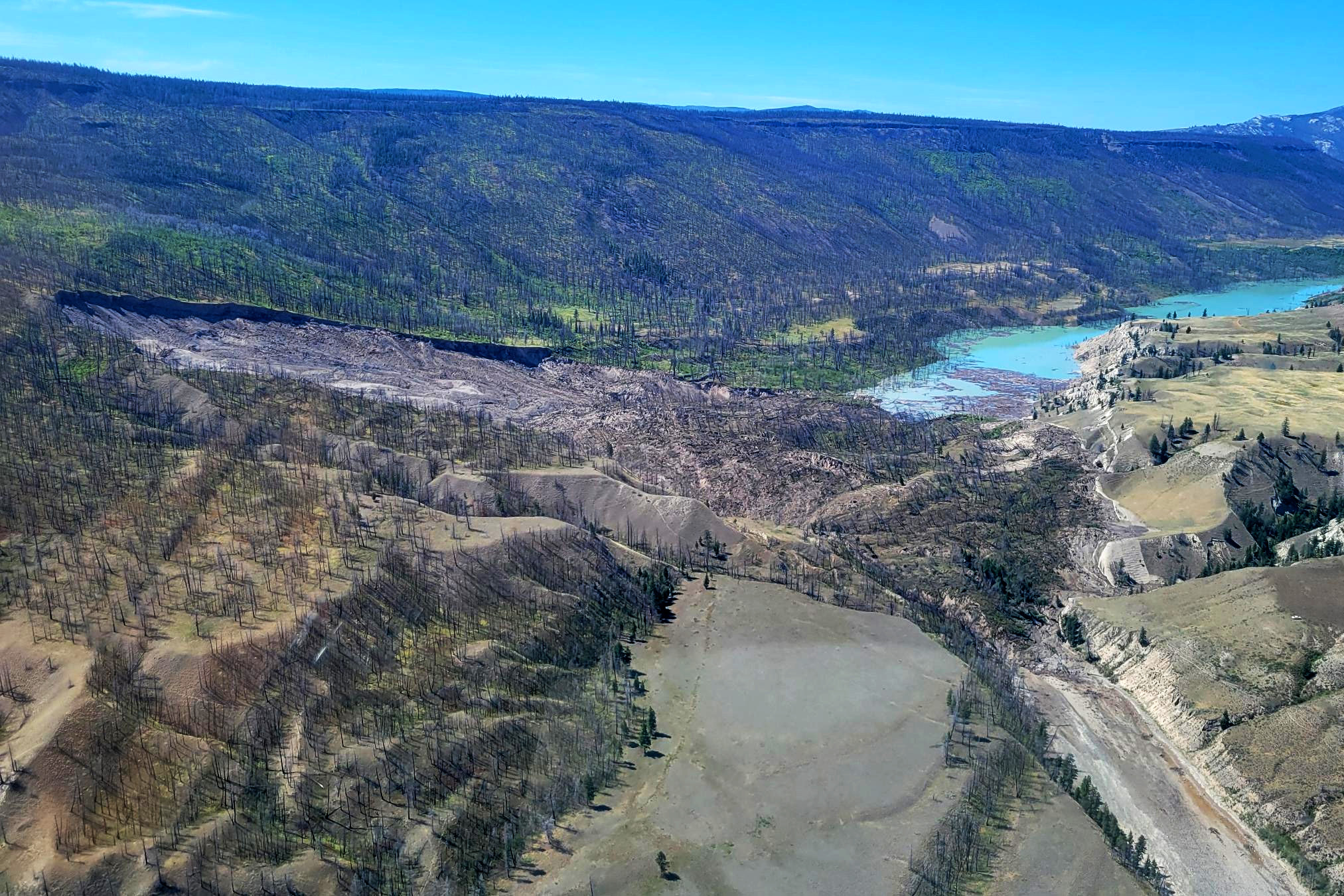
Landslides are common on the Chilcotin River, including large slides that can block the entire river for days. Farwell Canyon is known to the Tŝilhqot’in as Nagwentled "place of landslides." Check Province of BC and TNG for any updates to the current situation and take care with campsite selection. Also refer to "Appendix - Historical Landslides" below.
Grizzly bears are most common on the Chilko River, where they congregate in large numbers to feed on Sockeye salmon, but they can be seen anywhere in the region. Follow bear safe practices: keep a clean camp, manage scent attractants, cache food out of reach, make noise, travel in groups, carry bear spray, etc. There is a usually a recreation closure in September and October between Chilko Lake and Henry's Crossing to give the bears room to feed; check the TNG and BC Parks websites for updates. Other notable wildlife that could be seen include black bears, wolves, mountain goats, bighorn sheep, eagles, and pelicans.
Water should be packed for the whole trip. The entire trip is in cattle country, and side creeks originate from appealing sounding places such as Scum Lake, Alkali Lake and Poison Mountain. There may be a water source at Bull Canyon Provincial Park on Day 2, but check with BC Parks ahead of time as it can be out of service. As for possible water treatment, the water in the Chilko River is the clearest; the Chilcotin River has glacial silt and progressively passes through more ranches and mudbanks; the Fraser is almost always brown.
Leave no trace practices should be followed. Pack out all garbage including organics. River user numbers on the Chilcotin are at the point where packing out human waste is recommended.
Flows
The Chilcotin has one of the most predictable river flows in BC since its sources are the enormous glacier-fed Chilko and Taseko Lakes.Most groups do the Chilcotin multiday as a late summer trip once levels taper off a bit in late August and September. High water trips in late June, July and early August are possible if you have the skills and know the lines, but many groups stay away at this time of year because boat recovery from a swim or flip may take several kilometers. Flush drowning is a real risk. Low water shoulder season trips are also possible, with the potential for night temperatures below freezing.
To plan the full multiday check the Chilko, Taseko, Chilcotin and Fraser gauges. All sections are runnable at all levels, but judgement must be used for your group. Refer to separate descriptions for the Chilko River (IV) and Taseko River (IV) on BC Whitewater. Some groups choose to paddle the more technical Chilko and Taseko with unloaded rafts or kayaks, and launch the bigger gear rafts from the Chilko-Taseko confluence.
A medium flow for the Chilko River is 50-70cms (CHILKO RIVER AT OUTLET OF CHILKO LAKE 08MA002). The Taseko can be run a bit higher as it is not quite as continuous as the Chilko.
A medium flow for the Chilcotin River is 100-200cms (CHILCOTIN RIVER NEAR HANCEVILLE (08MB012). The Chilcotin River gauge with the longest record for statistics is CHILCOTIN RIVER BELOW BIG CREEK (08MB005); however, this gauge was discontinued after major floods near Big Creek in 2019. One limiting flow factor for many groups is the mandatory continuous class III-IV medium to high volume whitewater in Big John Canyon just above the Fraser confluence. It is difficult to stop, scout, or portage any of this section.
Look for the FRASER RIVER AT MARGUERITE (08MC018) to be around 2,500cms for a low stress float out. A level of 5,000cms will be scary with 1m high breaking waves on eddy lines, 20km/h current, and the campsite at the takeout could be flooded.
CHILKO RIVER AT OUTLET OF CHILKO LAKE (08MA002)
TASEKO RIVER AT OUTLET OF TASEKO LAKES (08MA003)
CHILCOTIN RIVER BELOW BIG CREEK (08MB005)
FRASER RIVER NEAR MARGUERITE (08MC018)
Shuttle
It's a big one: 5 hours each way for the Chilko-Chilcotin-Fraser shuttle, 3 hours each way for the Taseko-Chilko-Chilcotin-Fraser shuttle. Mostly on dirt roads. Get a GPS and backcountry map that shows forest roads. Any car should make it, but high clearance is recommended, and if the roads are wet AWD/4WD will be nice to have. Fuel up beforehand in Clinton or Williams Lake, and also check the location and hours of gas stations on the shuttle route (e.g. Tl'etinqox, Redstone). Williams Lake is a small city and the best place to get groceries and supplies. You can call around the outdoor stores in town for a possible shuttle service, but there is no dedicated shuttle company.
To get to the takeout from the south, turn left (west) off Highway 97 just north of Clinton onto Meadow Lake Road, and follow this for at least an hour down to the Gang Ranch suspension bridge over the Fraser River. Shortly after the bridge, turn left as the takeout is located 1km downstream (south) in Churn Creek Protected Area, down a small 4x4 road to a steep sandy beach on river right of the Fraser River just upstream of the Churn-Fraser confluence.
To get to the Chilko River put in at Henry's Crossing, there are a few options depending on how much you like driving on dirt roads. Probably the fastest is west through the private lands of Gang Ranch to Big Creek, and cross the Chilcotin River at Hanceville arriving at Highway 20 at Lee's Corner. Another option is again through Gang Ranch, but head to Highway 20 by crossing the Chilcotin River at Farwell Canyon arriving at Highway 20 at Riske Creek. If you do this, stop at the Farwell Canyon bridge to scout Farwell Rapids. If it has been raining, the ranch roads can be very slippery, so avoid Gang Ranch, cross back to river left of the Fraser and take the Dog Creek Road north to Highway 20. Whichever way you get to Highway 20, follow it west to Tatla Lake. Turn left (southeast) and follow Tatlayoko Road and Henry's Crossing Road to a bridge over the Chilko River at Henry's Crossing, a common put in. Unless it's closed for bears, you can also put in 15km upstream of Henry's Crossing on Chilko Lake at Gwe Da Ts’ih campground in Ts'ilɂos Park.
A typical Chiko-Chilcotin-Fraser shuttle route: through Gang Ranch, across Farwell Canyon Bridge, west on Highway 20, southeast at Tatla Lake to Henry's Crossing.
The route to the Taseko River put in at Davidson Bridge Recreation Site also starts west through Gang Ranch, but you stay on the south side of the Chilcotin River, all on dirt roads. There is nowhere to get gas or supplies. Do not try to short cut from Big Creek to Davidson Bridge, you have to drop down almost to the Chilcotin River at Hanceville before turning south again on Taseko Lake Road towards Nemiah Valley. You can also put in 30km upstream of Davidson Bridge at Taseko Lake with some exploratory 4x4 driving.
A typical Taseko-Chilko-Chilcotin-Fraser shuttle route.
On the water
The total trip length from Henry's Crossing on the Chilko River to Churn Creek on the Fraser River is ~215km (Chilko-Chilcotin-Fraser). The total trip length from Davidson Bridge on the Taseko River to Churn Creek on the Fraser River is ~230km (Taseko-Chilko-Chilcotin-Fraser). For either option, late summer raft trips generally take 5-7 days on the river, plus shuttle. A typical high water kayak trip is 3 days on the water.
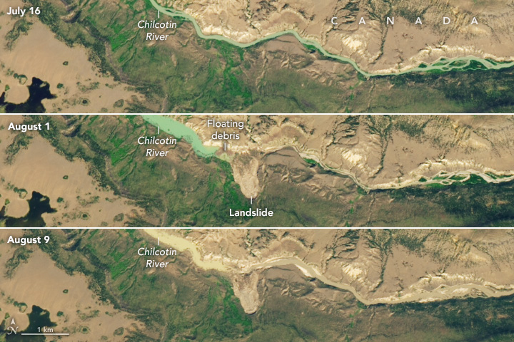
Important Note: The section between Hanceville and the Fraser confluence (Day 3 and Day 4) may have experienced changes from a large landslide on July 30, 2024 and resulting outburst flood on August 5th, 2024. The peak flow during this flood was estimated to be 3,000cms on the Chilcotin River, up to 30m above normal levels. This river description is all from trips before the landslide and flood.
Day 0 - Drive to put in
Camp at or shortly below the put in, as both rivers have significant canyons on Day 1.
Be respectful of TNG title lands
River left of the Chilko is private property from just below Chilko Lake until 10km downstream of Henry's Crossing.
Day 1 - Either 50 km on the Chilko River or 65 km on the Taseko River - Bridge put ins to Chilko-Taseko confluence
Both the Chilko River (from Henry's Crossing) and the Taseko River (from Davidson Bridge) contain sections of medium volume continuous class III-IV rapids that can be difficult to scout.
The most challenging whitewater on both rivers is in the final 20km down to the Chilko-Taseko confluence.
Bidwell Rapids on the Chilko River and Taseko Falls on the Taseko River are class IV at all levels and can be difficult to recognize to eddy out for scouting.
The Chilko River and Taseko River are described in more detail on their respective BC Whitewater pages.
Camp at the Chilko Taseko Junction Recreation Site, which is on a high bench on river left of the Chilko River at the Chilko-Taseko confluence. 4x4 boat ramp.
Day 2 - approximately 50km - Chilko-Taseko confluence to ranchlands
Semi-roadside class II-III and flatwater in ranch country.
Gap Rapids (III-IV): located under Siwash Bridge; a short constriction that gets boily at high water and also may collect wood
Chilko-Chilcotin confluence
Bull Canyon Provincial Park: roadside campground with possible water supply.
Alexis Creek bridge. Basic supplies 2km away in very small town of Alexis Creek.
Camp below the high water line on gravel bars, perhaps in the braided section between the road bridges at Alexis Creek and Hanceville. Most of the riverbanks from Siwash Bridge to Hanceville Canyon are private land or First Nations Reserve. At high water there are few legal campsites, but Day 2 and Day 3 can be combined.
Day 3 - approximately 50km -ranchlands to Big Creek
Hanceville bridge (Big Creek Road): boat ramp.
Hanceville Canyon (II-III): a limestone bluff on river left marks the start of read and run rapids for several kilometers before the river flattens out again.
Camp on river right just above the Big Creek confluence, it is easy to miss as Big Creek Rapids are just below. This campsite backs onto Big Creek Ecological Reserve.
Day 4 - 35 km - Big Creek to Chilcotin-Fraser confluence
Big Creek Rapids (III+): located just below Big Creek confluence; read and run long braided wave trains.
Pothole Ranch cabins: river right just before Farwell Rapids. Damaged in 2024 floods. River access with a short hike to the road.
Farwell Rapids (III-IV): located just above Farwell Canyon bridge and continue underneath; big hydraulics under the bridge at high water.
Junction Sheep Range Provincial Park: river left from just below Farwell Rapids down to the Chilcotin-Fraser confluence; no services.
Big John Canyon (III-IV): continuous rapids for the final 5km of the Chilcotin River down to the Chilcotin-Fraser confluence; scouting and portaging is not practical due to deep canyon.
Camp on gravel bars near the Chilcotin-Fraser confluence.
Day 5 - 30km - Chilcotin-Fraser confluence to Churn Creek takeout
Mostly flatwater with minor very high volume class II-III.
Take out at a steep sandy beach on river right in Churn Creek Protected Area, 1km downstream of Gang Ranch suspension bridge, just above the Churn-Fraser confluence.
It is possible to continue further down the Fraser River, if you have a plan to deal with the class V rapids downstream (Big Bar, Bridge River, Hells Gate).
Chilko Lake. Elevation 1,172m.
Chilko Lake. (photo Rocky Contos)
A common put in at Henry's Crossing over the Chilko River. Elevation 1,135m.
The lower half of Bidwell Rapid (IV) on the Chilko River at a high flow (~110cms on CHILKO RIVER AT OUTLET OF CHILKO LAKE 08MA002). (photo Graham Gerry)
Bidwell Rapid on the Chilko River at medium water (~60cms on CHILKO RIVER AT OUTLET OF CHILKO LAKE 08MA002). Note the scouting eddy in calm water well above the rapid on river left. Once around the blind corner it is usually too late to stop. (Photo Dave Wortley)
Bidwell Rapid on the Chilko River at low water (~45cms on CHILKO RIVER AT OUTLET OF CHILKO LAKE 08MA002).
The runout of Bidwell Rapid on the Chilko River at high water (~100cms on CHILKO RIVER AT OUTLET OF CHILKO LAKE 08MA002).
Lava Canyon on the Chilko River.
Taseko Falls (IV) on the Taseko River at high water (~100cms on TASEKO RIVER AT OUTLET OF TASEKO LAKES 08MA003). Normally scouted from the boulders along river right. At low water the pourover rock in the foreground is exposed. (photo Graham Gerry)
Taseko Falls (IV) on the Taseko River at high water. (photo Graham Gerry)
Chilko-Taseko confluence. Chilko Taseko Junction Recreation Site is visible on the left. Elevation 819m.
Chilko-Taseko confluence.
Gap Rapids (III-IV) at low water. This pinch gets pretty boily at high water.
Eagles at the Chilko-Chilcotin confluence. Elevation 735m.
The limestone bluffs at the entrance to Hanceville Canyon (II-III), burned in 2017.
Approaching Big Creek. Bedrock cliffs on river left, boulders on river right from the Big Creek debris fan.
Big Creek campsite. Elevation 508m.
Entering Farwell Canyon.
Historic Pothole Ranch on river right at Nagwentled / Farwell Canyon. Photo from 2019, this was damaged in the 2024 floods. The road bridge and Farwell Rapids (III-IV) are not far below.
Farwell Rapids (III-IV) from the bridge. Depending on the level, it may be hard to stop to scout and still be in a position to make the line. At low water you can scout from river right. At high water you could stop at Pothole Ranch and hike over to scout from the bridge. The wave train continues under the bridge.
Farwell Canyon.
Entering Big John Canyon approximately 5km above the Chilcotin-Fraser confluence.
Part of Big John Canyon (III-IV) at low water.
Chilcotin-Fraser confluence. Elevation 350m.
The float out on the Fraser River.
View looking upstream at the Gang Ranch suspension bridge over the Fraser River. The takeout is 1km below on river right.
View looking downstream at the take out on river right just above Churn Creek in Churn Creek Protected Area (foreground). The bench downstream of Churn Creek is private land owned by the Stwecem’c Xget’tem First Nation (background).
Prickly pear cactus at Churn Creek. Elevation 330m.
Shuttling through Gang Ranch.
Appendix - Historical Landslides
2024:
On July 30, 2024 a landslide 30m deep occurred on the Chilcotin River about 20km upstream from Farwell Canyon bridge, which blocked the entire river for 6 days. A rafter was caught in the landslide but thankfully both he and his dog escaped. (photo Province of BC)
Initial landslide breach on August 5, 2024. (Province of BC)
Peaks flows on the Chilcotin River were estimated at 3,000cms. (Province of BC)
Farwell Canyon during the flood. (photo Tŝilhqot’in National Government / York University)
Flood debris passing through Big John Canyon on August 5, 2024. (photo Province of BC)
The flood debris reaching the Chilcotin-Fraser confluence on August 5, 2024. (photo Province of BC)
Flow continued through the landslide breach at a reduced rate on August 7, 2024. (photo Province of BC)
2024 landslide from Landsat 8. (photo NASA Earth Observatory)
The rapid had cleared by early September (photo). Then, a smaller secondary landslide happened on September 16, 2024, that temporarily blocked the Chilcotin River again and raised water levels by about 7m. This blockage has since been breached but it has raised the turbidity in the river significantly.
"Access to the area, as outlined in red on the attached map, is hereby rescinded effective September 18, 2024 to January 31, 2025." (Province of BC)
2004:
2004 photo of a breached landslide in Farwell Canyon. (photo Rocky Contos)
1964:
1964 landslide on the Chilcotin River. This slide occurred on August 19, 1964. It was reported to be 70 feet high and fish passage was observed on August 29. (photo DFO Trade News October 1964)
Prehistory:
Clauge et al., 2021, "A huge flood in the Fraser River valley, British Columbia, near the Pleistocene Termination."
Friele et al., 2024, "The Texas Creek landslide, southwestern British Columbia: new ages and implications for the culture history and geomorphology of the mid-Fraser River region."